The Kahnawà:ke Environment Protection Office (KEPO) wishes to inform the community that drone flights will be conducted throughout June and July as part of an upcoming flood mapping project along creeks within the Territory.
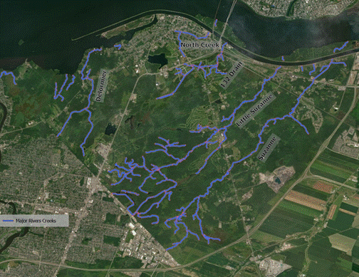
KEPO staff will be piloting the drone and focusing on narrow corridors along the Suzanne River, Little Suzanne River, North Creek, 132 Drain, and Delorimier Creek.
A LiDAR camera will be used to collect elevation data and support the creation of detailed maps of these areas. No photos of community members will be taken during the LiDAR operation. KEPO employees conducting the flights hold advanced drone pilot certification, and the drone being used is categorized as over 250 grams. KEPO staff will be on site during flights and will be clearly identifiable by safety vests.
This project will support the development of flood hazard maps for areas surrounding the creeks. Modeling will be completed for key flood events (1-in-20, 1-in-50, and 1-in-100-year scenarios). The project is part of KEPO’s ongoing climate change adaptation efforts and is funded through the Indigenous Climate Monitoring Program.
The Kahnawake Peacekeepers will be notified on the days when drone operations take place. For more information, please contact KEPO at 450-635-0600.